


Stevenson 6 + variante

Chabard
User

Length
24 km

Max alt
1502 m

Uphill gradient
631 m
Km-Effort
32 km

Min alt
1018 m

Downhill gradient
477 m
Boucle
No
Creation date :
2025-07-01 07:10:13.0
Updated on :
2025-07-01 14:28:01.84
7h16
Difficulty : Difficult

FREE GPS app for hiking
 SityTrail
IGN / Geographical institutes
SityTrail Plus
The world is yours!
About
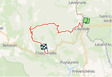
Trail Walking of 24 km to be discovered at Occitania, Lozère, La Bastide-Puylaurent. This trail is proposed by Chabard.
Description
La Bastide Puylaurent - Moure de La Gardille - Sources de l’Allier - Chasseradés
Positioning
Country:
France
Region :
Occitania
Department/Province :
Lozère
Municipality :
La Bastide-Puylaurent
Location:
Unknown
Start:(Dec)
Start:(UTM)
571898 ; 4938011 (31T) N.
Comments